Syllabus
G&ES 390 Remote Sensing & Digital Image Processing
Fall 2013
Northeastern Illinois University
Basic Information
- Class Delivery: Online
- Instructor: Mike Ribant; (773) 442-5648; Email: M-Ribant@neiu.edu
- Instructor Office Hours: Tuesdays 3:00-5:00pm, or by appointment; Brommel, Room 344H
- Suggested Text (NOT required): Introduction to Remote Sensing, 2011, 5th Edition
James B. Campbell and Randolph H. Wynne - ISBN 978-1-60918-176-5
Course Overview
- Students will learn the fundamentals of digital analysis, interpretation and application of satellite remotely sensed imagery. Students will develop an understanding of the available data and processing techniques used to understand environmental systems.
The specific objectives of the course are as follows:
- Develop a basic understanding of how remotely sensed and geographic data are represented;
- Introduce students to the basic concepts, data, and methods of remote sensing and imaging processing;
- Learn about the properties of light as well as the sensors and platforms used to analyze it;
- Learn how to obtain and analyze RS and digital data to produce thematic maps;
- Learn the concepts of landscape patterns and the methods used to decipher them;
- At the end of the class, through weekly lab projects and a final individual project, students will be able to conduct analyses of earth systems using satellite remote sensing and digital imaging data using ERDAS Imagine software.
Assessment (weighted as follows):
- Midterm Exam: 20% U&G
- Lab Exercises (9): 60% U; 40% G
- Final Exam: 60% U; 40% G
- Final Project (Grad students only): 20% G
Exams (40%):
- There will be 2 exams: 1 midterm and 1 final exam. Exams are not cumulative. Each exam is weighted equally at 20% and taken together will represent 40% of your grade. Exam questions will be multiple choice or short answer and will cover material covered in class, including any videos or lab exercises. A list of terms to study for will be provided before each exam. You must take the exam at the assigned time. If you are concerned about missing an exam please contact me well in advance. My intent with exams is to help further your understanding of the material, not necessarily to assess your ability to remember material within a specified time frame. Thus, both exams will be take home, open-book exams where you will be given 2 or 3 days to complete and return them.
Lab Assignments (60% for Undergrads/40% for Graduate Students):
- There will be 10 lab assignments based on either readings or subjects covered in class. Your lowest assignment grade will be dropped, and the other nine assignment scores will comprise your total lab grade (60%U/40%G). Assignments will require a basic knowledge of materials covered in class and are due at the beginning of class on the due date. There will be no makeup lab assignments. Labs will be assigned on Monday mornings and due the following Monday at noon.
Final Project (20% - Graduate Students Only):
- Graduate students will turn in a final project evidencing some of the major methodologies learned in class. More details will be provided later in the semester. Undergraduate students are not required to do a final project.
Final grades will be determined as follows:
- A (more than 90%), B (between 80% and 90%), C (between 70% and 80%), D (55% and 70%), and F (less than 55%).
Class Policies
- Class Etiquette: An online learning environment has its advantages, but a drawback of it is that simple communication can be easily misconstrued. Please be respectful, courteous and tolerant in your postings. Humor is fine, sarcasm probably isn 't.
- Late Work: Please be advised that there will be no make-up lab work. Also, there will be no make-up for the exams unless you experience a documented emergency or an excused absence. Incomplete grades will not be given.
- Academic Honesty: Be honest. Cheaters never prosper, especially here.
- Questions and/or Concerns: Emails are more than welcome and I will try to respond to them in a timely manner (definitely within 24 hours, usually sooner). If you are having problems with the course material, please contact me as soon as possible.
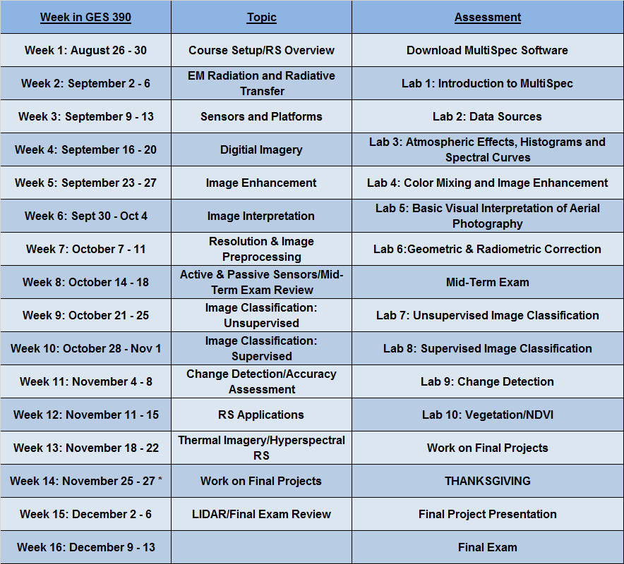
Schedule